


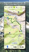
US Topo Maps
US Topo Maps ၏ ရွင္းလင္းခ်က္
USA အတွက် အကောင်းဆုံးရရှိနိုင်သောမြေပုံများနှင့် ဝေဟင်ပုံရိပ်များကို အခမဲ့ဝင်ရောက်အသုံးပြုနိုင်သည့် ပြင်ပလမ်းကြောင်းပြအက်ပ်ကို အသုံးပြုရလွယ်ကူသည်။
ပြီးပြည့်စုံသော ခရီးစဉ်ကို စီစဉ်ရန်နှင့် ပြီးပြည့်စုံသော ခရီးစဉ်ကို စီစဉ်ရန် မြေပုံအလွှာ 30+ (topos၊ ဝေဟင်၊ ပင်လယ်မြေပုံများ၊ ...)
သင်၏ Andoid ဖုန်း/Tablet အား တောတွင်းသို့ အော့ဖ်လိုင်း ခရီးစဉ်များအတွက် ပြင်ပ GPS အဖြစ် ပြောင်းလဲပါ။
အခြားရင်းမြစ်များမှ မြေပုံများကို အလွယ်တကူ ထည့်ပါ (GeoPDF၊ GeoTiff၊ WMS၊ ... ကဲ့သို့သော အွန်လိုင်းမြေပုံဝန်ဆောင်မှုများ)
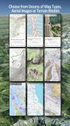
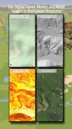
USA အတွက် ရရှိနိုင်သော အခြေခံမြေပုံအလွှာများ
• USGS အမျိုးသားမြေပုံ Topo
• USGS အမျိုးသားမြေပုံ ရုပ်ပုံ Topo
• USGS အမျိုးသားမြေပုံပုံရိပ်
• USGS NAIP HiRes ပုံများ
• USGS Topo ရိုးရာ DRGs- စကေး 1:250,000၊ 1:100,000၊ 1:63,000 နှင့် 1:24,000/25,000 တွင် USA ၏ topo မြေပုံများ၏ ချောမွေ့စွာလွှမ်းခြုံမှု
• FSTopo သစ်တောမြေပုံများ
• NOAA Nautical RNC ဇယားများ
• National Elevation Maps (တောင်ကုန်း၊ တောင်စောင်းမြေပုံ၊ ရှုထောင့်မြေပုံ)
ကမ္ဘာတစ်ဝှမ်း အခြေခံမြေပုံအလွှာများ
• OpenStreetMaps (မတူကွဲပြားသောမြေပုံပုံစံ ၅ ခု) ကို space save vectorformat တွင်လည်းဒေါင်းလုဒ်လုပ်နိုင်သည်။
• Google Maps (ဂြိုလ်တုပုံများ၊ လမ်းနှင့် မြေပြင်မြေပုံ)
• Bing Maps (ဂြိုလ်တုပုံများ၊ လမ်း-မြေပုံ)
• ညအချိန်တွင် ကမ္ဘာမြေ
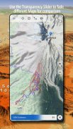
basemap အလွှာကို ထပ်ဆင့်အဖြစ် သတ်မှတ်ပြီး မြေပုံများကို တစ်ခုနှင့်တစ်ခု ချောမွေ့စွာ နှိုင်းယှဉ်ရန် ပွင့်လင်းမြင်သာမှု fader ကို အသုံးပြုပါ။
အခြားအရင်းအမြစ်များမှမြေပုံများထည့်ပါ
• GeoPDF၊ GeoTiff၊ MBTiles သို့မဟုတ် Ozi (Oziexplorer OZF2 & OZF3) တွင် raster မြေပုံများကို တင်သွင်းပါ။
• WMS သို့မဟုတ် WMTS/Tileserver အဖြစ် ဝဘ်မြေပုံဆွဲခြင်းဝန်ဆောင်မှုများကို ထည့်ပါ။
• OpenStreetMaps ကို Vectorformat တွင် တင်သွင်းပါ၊ ဥပမာ- အချို့ GBs များအတွက် USA ကို အပြီးသတ်ပါ။
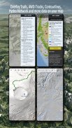
ရနိုင်သော US map Overlays - အခြားအခြေခံမြေပုံသို့ နောက်ထပ်အချက်အလက်များထည့်ပါ-
• အများသူငှာ မြေယာပိုင်ဆိုင်မှု (PAD-US 3)၊
• National Hydrographic Dataset
• မော်တော်ယာဉ်အသုံးပြုမှုမြေပုံ (USDA)
• Elevation Contourlines
• 4WD Trails
• လမ်းများ
• လမ်းများ၊ မီးရထားများ၊ လေဆိပ်များ
ကမ္ဘာတစ်ဝှမ်းရှိ ထပ်ဆင့်များကို ရနိုင်သည်-
• Hillshading ထပ်တင်ခြင်း။
• 20m Contourlines
• OpenSeaMap
ပြီးပြည့်စုံသောမြေပုံမရှိပါ။ မတူညီသောမြေပုံအလွှာများကြားတွင် ပြောင်းရန် သို့မဟုတ် စိတ်ဝင်စားစရာအကောင်းဆုံးလမ်းကြောင်းကိုရှာဖွေရန် နှိုင်းယှဉ်မြေပုံများအင်္ဂါရပ်ကိုသုံးပါ။ အထူးသဖြင့် ရှေးရိုးအစဉ်အလာ DRG များတွင် ခေတ်မီမြေပုံများတွင် ပျောက်နေသော လမ်းကြောင်းသေးသေး သို့မဟုတ် အခြားအင်္ဂါရပ်များစွာ ပါရှိသည်။
ပြင်ပ-လမ်းညွှန်မှုအတွက် အဓိကအင်္ဂါရပ်များ-
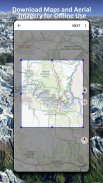
• အော့ဖ်လိုင်းအသုံးပြုမှုအတွက် မြေပုံဒေတာကို ဒေါင်းလုဒ်လုပ်ပါ။
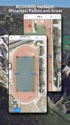
• လမ်းများနှင့် ဧရိယာများကို တိုင်းတာပါ။
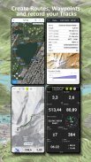
• Waypoints ကို ဖန်တီးပြီး တည်းဖြတ်ပါ။
• GoTo-Waypoint-Navigation
• လမ်းကြောင်းများကို ဖန်တီးပြီး တည်းဖြတ်ပါ။
• လမ်းကြောင်း-သွားလာခြင်း (Point-to-Point Navigation)
• ခြေရာခံမှတ်တမ်းတင်ခြင်း (အမြန်နှုန်း၊ အမြင့်နှင့် တိကျမှုပရိုဖိုင်ဖြင့်)
• odometer၊ ပျမ်းမျှအမြန်နှုန်း၊ bearing၊ elevation စသည်တို့အတွက် နယ်ပယ်များပါရှိသော Tripmaster
• GPX/KML/KMZ သွင်းကုန်/ပို့ကုန်
• ရှာဖွေရန် (နေရာအမည်များ၊ POIs၊ လမ်းများ)
• အမြင့်နှင့် အကွာအဝေးကို ရယူပါ။
• Map View နှင့် Tripmaster (ဥပမာ အမြန်နှုန်း၊ အကွာအဝေး၊ သံလိုက်အိမ်မြှောင်၊ ...)
• Waypoints၊ Tracks သို့မဟုတ် Routes (eMail၊ Dropbox၊ WhatsApp၊ ..) မှတဆင့်မျှဝေပါ။
• WGS84၊ UTM သို့မဟုတ် MGRS/USNG (Military Grid/ US National Grid) တွင် သြဒိနိတ်များကို အသုံးပြုပါ။
• သီချင်းပြန်ဖွင့်ခြင်း။
• နှင့် များစွာသော ...
တောင်တက်ခြင်း၊ စက်ဘီးစီးခြင်း၊ စခန်းချခြင်း၊ တောင်တက်ခြင်း၊ စီးနင်းခြင်း၊ နှင်းလျှောစီးခြင်း၊ ကနူးလှေစီးခြင်း၊ အမဲလိုက်ခြင်း၊ နှင်းမိုဘိုင်းခရီးသွားများ၊ offroad 4WD ခရီးစဉ်များ သို့မဟုတ် ရှာဖွေရေးနှင့် ကယ်ဆယ်ရေး (SAR) ကဲ့သို့သော ပြင်ပလှုပ်ရှားမှုများအတွက် ဤလမ်းကြောင်းပြအက်ပ်ကို အသုံးပြုပါ။
WGS84 datum ဖြင့် လောင်ဂျီတွဒ်/လတ္တီတွဒ်၊ UTM သို့မဟုတ် MGRS/USNG ဖော်မတ်တွင် စိတ်ကြိုက်လမ်းကြောင်းများ ထည့်ပါ။
GPX သို့မဟုတ် Google Earth KML/KMZ ဖော်မတ်ဖြင့် တင်သွင်း/တင်ပို့/မျှဝေပါ။
မိုးစတင်/ရပ်သည့်အခါ တိကျသောခန့်မှန်းချက်များကို ပြုလုပ်ရန် ကာတွန်း NEXRAD မိုးရေဒါကို ကြည့်ပါ။
ကျေးဇူးပြု၍ support@atlogis.com သို့မေးခွန်းများ၊ မှတ်ချက်များနှင့်အင်္ဂါရပ်တောင်းဆိုမှုများပေးပို့ပါ။
US Topo Maps - APK သတင္းအခ်က္အလက္
APK ဗားရွင္း: 7.8.0package: com.atlogis.northamerica.freeUS Topo Maps ၏ ေနာက္ဆုံးဗားရွင္း
အျခား ဗားရွင္းမ်ား


က႑တူအက္ပ္မ်ား

သင္ႏွစ္သက္ႏိုင္သည္မ်ားမွာ...


